Hiking this challenging trail around Mt Kanchenjunga yields rewards that more popular routes don’t, including stays in traditional teahouses that few foreigners ever see, writes Stewart Butler in BBC Travel on June 25, 2015.
![]()
The forgotten mountain
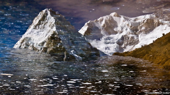
Ask people to name the three highest mountains in the world, and few get past Mount Everest and K2. At 8,586m, Mt Kanchenjunga is only about 300m lower than Everest, but for all intents and purposes, the world’s third-highest peak has been forgotten. Lying on the border between eastern Nepal and the Indian state of Sikkim, Kanchenjunga is worshipped as a tutelary spirit by the Sikkimese. The mountain was first successfully tackled by British climbers in 1955, but they, like all who came after them, stopped just short of the summit out of respect for the locals’ belief that the mountaintop is sacred. (Credit: Stuart Butler)
World-class trekking
Kanchenjunga, a name that originates from Tibetan, means the “five treasures of snow” and corresponds to the massif’s five distinct peaks. Like many mountains in Nepal, Kanchenjunga offers world-class trekking. But unlike some of the country’s more popular routes, which can become overrun in the prime autumn and spring hiking seasons, the trails to and around Kanchenjunga’s two basecamps remain delightfully free of foreign visitors – likely due to the difficulty and expense of reaching the area. Kanchenjunga is well off the established tourist trail and reaching a trailhead requires several days of road travel or a costly flight. In addition, trekkers must have proper permits and be accompanied by a recognized guide company, generally arranged in Kathmandu. (Credit: Stuart Butler)
Two ways up
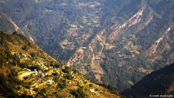
Trekkers can choose one of two routes: to the south or north basecamp. The trek to the 5,140m-high north basecamp is longer, but offers more time in the high mountains. It’s also possible, over the course of roughly 25 days, to link the two routes via a couple of high passes. I trekked to the 4,730m-high south basecamp, starting in the small market town of Taplejung, which is located a two-day drive from Kathmandu. It took me nine days to reach basecamp, and another five for the hike back. For the first four days, the trail coursed through small villages, patches of tropical forest and terraced fields like the one pictured here. Crops vary depending on the altitude, with rice grown at lower levels and barley higher up. The big cash crop in the region is cardamom. (Credit: Stuart Butler)
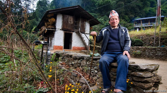
Teahouse trekking
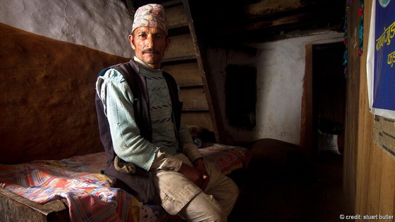
Most people travel with porters and camping gear, but you can also stay in teahouses. In popular trekking areas such as Annapurna, Everest and Langtang, teahouses cater almost exclusively to foreign trekkers and are increasingly sophisticated, sometimes even offering hot showers and wi-fi. In the Kanchenjunga region, however, the teahouses are used mainly by local shepherds, traders and porters, and are simply villagers’ homes with a room or two for rent. Conditions can be basic – you’ll get a bed and a shared toilet – but staying in them allows visitors the chance to get to know locals in a way that’s rarely possible on more popular routes. The man pictured here owned this home and teahouse in the village of Phumphe. (Credit: Stuart Butler)
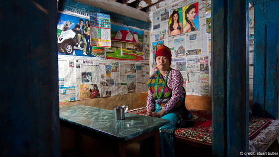
Teahouse style
Teahouse decor has its own distinctive style. Newspaper is commonly used as wallpaper, and homes are further adorned with posters of fantasy American homes, fast cars or, as in the case of this teahouse in the village of Mamanke, images of Indian and Nepalese film and pop stars. The woman pictured here is a neighbour who stopped by for a chat and a cup of tea. (Credit: Stuart Butler)
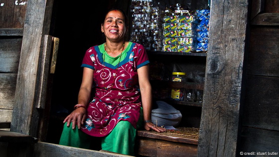
Sweets and shops
While still difficult to reach, this remote region is becoming increasingly accessible. As such, many villages have at least one tiny shop selling a few basic provisions, including biscuits and sweets. The shopkeeper pictured here resides in Phumphe. (Credit: Stuart Butler)
Yeti footprints
In Yamphudin, the final village en route to the south basecamp, the man pictured told me that he and his son once walked over a high mountain pass that leads to Sikkim. On the way home, they spent a night in a remote shepherd’s hut on the edge of the tree line. When they went outside the next morning, they discovered giant footprints in the snow circling the hut and disappearing into the forest. He and the boy were too scared to follow the tracks, he said, as both believed they were the prints of a yeti. Many villagers, in fact, believe that yetis exist in the region. (Credit: Stuart Butler)
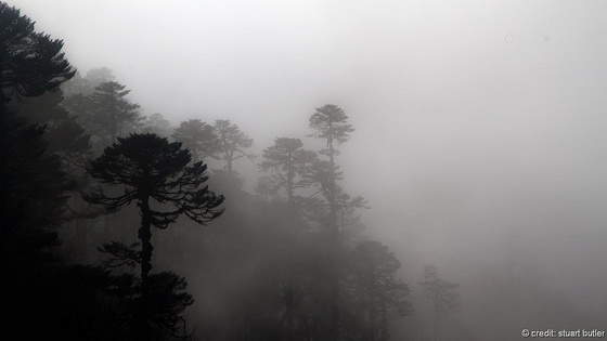
A misty forest
Beyond Yamphudin, the trail entered pine forests where rhododendrons blistered with red, pink and white flowers. Almost every tree was covered in Spanish moss, which hung from the branches like an old man’s beard. A dense, cloudy mist filled the air at all times, obscuring the mountain vistas and lending a silent, spooky feel to the forests. (Credit: Stuart Butler)
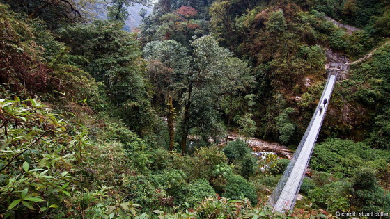
A bridge to the mountains
The trail then climbed sharply for a couple of hours, crossed a 2,540m pass and descended through tangled pine and rhododendron forests where red pandas and pheasants reside. We came to a modern suspension bridge spanning a river. These kinds of bridges have appeared only in the past couple of years. Prior to that, shepherds crossed the rivers on flimsy log bridges. (Credit: Stuart Butler)
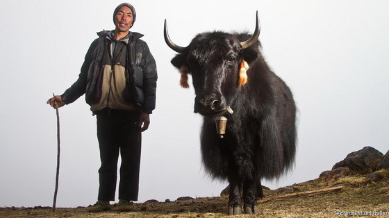
Symbols of the high Himalaya
In the summer (June to August), shepherds live with their yaks – symbols of the high Himalaya – in high pastures located up to and above 5,000m. As autumn approaches, the shepherds and their animals slowly descend from the mountains, seeking milder weather. More often than not, these animals are actually a much stronger cross-breed of yaks and cows; pure-bred yaks are quite rare in Nepal. Locals often make cheese from the animals’ milk, and yak meat is eaten in much of Nepal. (Credit: Stuart Butler)
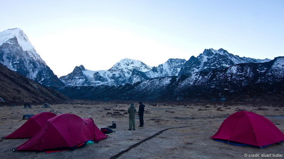
Sleeping outdoors
This photo was taken at dawn at Ramche, the highest night stop on the trek at 4,580m. The tents froze over during the night, but by midday, hikers could wear T-shirts. (Credit: Stuart Butler)
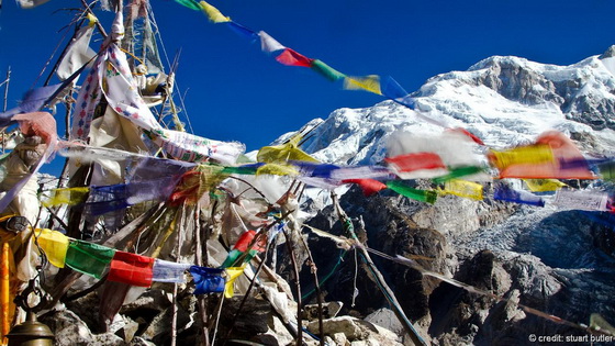
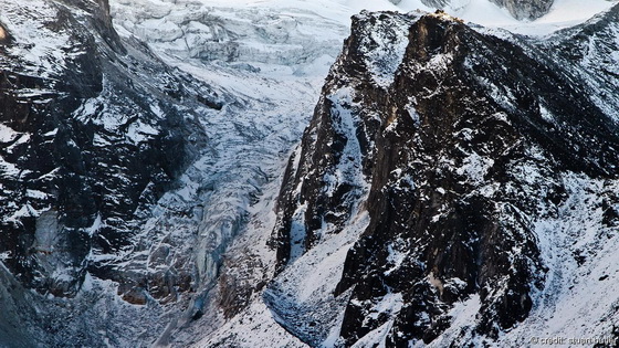
The end of the road
The trekking route to the south basecamp ends at Oktang, where a mixed Buddhist/Hindu shrine (pictured) overlooks both the basecamp and the upper part of the Yalung Glacier. Continuing any farther requires mountaineering experience and equipment. Unless you’re prepared to reach the high passes to get to the north basecamp route, you have little option but to spin around and retrace your steps back to where you started. For me, that moment made for mixed emotions. The thought of enjoying a hot shower, donning clean clothes and checking emails filled me with anticipation, but I was sad to leave behind this incredible world of frozen glaciers, misty forests and villagers who open their homes and speak with passion about yetis. (Credit: Stuart Butler)


Comments are closed.